


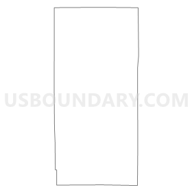
Beatty Twp. Voting District, St. Louis County, Minnesota
About
Outline
Summary
| Unique Area Identifier | 604256 |
| Name | Beatty Twp. Voting District |
| County | St. Louis County |
| State | Minnesota |
| Area (square miles) | 79.97 |
| Land Area (square miles) | 65.29 |
| Water Area (square miles) | 14.68 |
| % of Land Area | 81.65 |
| % of Water Area | 18.35 |
| Latitude of the Internal Point | 47.97564630 |
| Longtitude of the Internal Point | -92.61213810 |
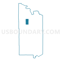
Maps


Graphs
Select a template below for downloading or customizing gragh for Beatty Twp. Voting District, St. Louis County, Minnesota


Neighbors
Neighoring Voting District (by Name) Neighboring Voting District on the Map
- Field Twp. Voting District, St. Louis County, MN
- Leiding Twp. Voting District, St. Louis County, MN
- Owens Twp. Voting District, St. Louis County, MN
- Portage Twp. Voting District, St. Louis County, MN
- Unorg. Prct. 12, St. Louis County, MN
- Unorg. Prct. 13, St. Louis County, MN
Top 10 Neighboring County Subdivision (by Population) Neighboring County Subdivision on the Map
- Leiding township, St. Louis County, MN (400)
- Field township, St. Louis County, MN (391)
- Beatty township, St. Louis County, MN (372)
- Owens township, St. Louis County, MN (263)
- Northeast St. Louis UT, St. Louis County, MN (248)
- Portage township, St. Louis County, MN (170)
- Gheen UT, St. Louis County, MN (18)